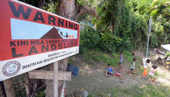
THE CITY Disaster Risk Reduction and Management Office (CDRRMO) Operations and Warning Division installed visible warning devices along the landslide-affected portion of Davao-Bukidnon Road in Marilog District.
Also, the office recommended a thorough geotechnical survey before construction activities occur.
CDRRMO head Alfredo Baloran, in an interview, said his office conducted a hazard and risk assessment in Barangay Baganihan, Marilog, on June 8, 2023, amid the mass landslides that affected national and barangay roads.
The assessment evaluated the risks posed by the mass movement and provided suitable recommendations to address the underlying issues.
Baloran said, “Nag-conduct ta og follow up inspection. Delikado gyud if there is continuous heavy rainfall, duna’y tendency ma aggravate ang situation sa kalsada (We conducted a follow-up inspection. It is dangerous if there is a continuing heavy rainfall and a tendency to aggravate the situation on the road).”
He said while the Department of Public Works and Highways is negotiating adjacent lots for rerouting of the national highway, “Gahangyo ta as preventive measures ang pag-install of early warning system at least 100 meters away from the danger zone to alert the motorists passing through the landslides-affected area.”
Baloran said areas affected by the landslides are foggy at night and have zero visibility, that’s why it could pose dangerous risks to motorists.
“Before muabot sa lugar ma alert na for them to make necessary precautions (Before reaching the location, they will be alerted to make necessary precautions),” he said.
The recommended visible warning devices included solar lights or blinkers.
The geotechnical survey, meanwhile, is recommended to expedite slope stabilization.
The continued area monitoring for further mass movement through the observation of tension cracks, tilted vertical structures, forward-rotated trees, and concrete road cracks is also advised.
The CDRRMO Operations and Warning Division reported the affected area in Sitio New Calinan, Baganihan, has experienced partial damage in a section of the road due to mass wasting triggered by heavy rainfall.
At the site, observers noted the presence of debris, including soil materials, concrete fragments, utility posts, sheet piles, and sandbags.
The terrain is steep, with an elevation of approximately 1100-1200 meters above sea level (ASL), and it is situated around 800 meters away from the Epol River.
The geological composition of the area consists of well-consolidated sandstone shale, conglomerate, calcarenite, and silty limestone.
During a barangay session, officials proposed using the other side of the national road as an alternative route by extracting materials for road construction.
Negotiations with the property owner for approval and resolution drafting by the barangay are underway.
Authorities actively installed caution tapes in the area to ensure public safety. In Purok 3, Katandungan, the barangay road has also suffered damage due to landslides caused by heavy rainfall.
The area has dense vegetation, steep slopes, and tension cracks. It is situated approximately 920 meters above sea level (ASL) and 200-300 meters from a tributary of the Kulaman River.
Given the steep slopes and soft underlying materials, the assessment classified this area as highly susceptible to landslides.
Based on the detailed susceptibility maps provided by the DENR-Mines and Geosciences Bureau (DENR-MGB), both assessed areas in Sitio New Calinan and Purok 3, Katandungan, exhibit characteristics that indicate moderate to high susceptibility to landslides.

